Spontaneous week in Hardangervidda in July 2023

Intro

Me and the family were in Greece this summer, seeing my wife’s relatives for the first time since before Covid. We had 2,5 weeks planned, but when it was time to go home neither my wife or C felt that they’d had enough of Greece. My wife had two weeks of additional vacation, and since we had bought “flex” tickets we rescheduled their flight to 9 days later. I had to go home with my son though, since he was going away to camp that week, and my oldest daughter wanted to get back home. With my son away at camp, and my oldest daughter an 18 year old who preferred to have the house to herself I suddenly had a week with nothing planned and no one to take care of. I already had a route planned in Hardangervidda from 2018, when I ended up canoeing in Femundsmarka instead, and decided to go there.

Since my wife and my in-laws were in Greece and my parents away on a trip I would be the closest relative to to take care of my son if he would get sick during camp. My daughter could take care of him until I could get back, but not for a whole week. Because of this I would need a way to keep in touch, and since there’s hardly any cellphone reception I decided to buy a Garmin inReach Messenger. It was really great, and though I like the thought of being totally disconnected in the mountains, it was actually pretty nice to be able to keep in touch with my family during the week.

Sunday

I dropped off my son at camp at 14.00, and immediately started driving towards Hardangervidda / Middalsbu. The trip was estimated to take 10h20 min.

I drove through Gothenburg and followed the highway north along the coast. I took a break before the Norwegian border to buy a hamburger and to refuel the car.

In Norway the route started with highways, but you were still only allowed to drive at 90km/h. Norway has extremely expensive speeding tickets, so I meticulously kept the speed limit. As I went further inland more and more distances would have a maximum speed of between 60-80km/h.

I was quite tired, and had thought about pausing and pitching the tent somewhere on route. But I wanted to be able to hike right away the next day, so I decided to drive on. I had time to regret my decision a couple of times, but the next day I was glad that I drove the whole way to Middalsbu.

Around 23.00, I saw a figure hitchhiking in the middle of nowhere. At first I wasn’t going to pick him up, but then I thought I would have liked someone to stop if I wanted a lift.

I didn’t think about how late it was, and in retrospect I probably wouldn’t pick someone up so late in the middle of nowhere again. It was a man who was going to Bergen, where someone had offered to give away a sleeping bag. He carried some stuff and a rolled up matress with him, and was very vague when I asked where he came from. I got the feeling he was homeless.

I offered to drop him off in one of the villages we passed, and explained several times where I was going, and that I was not going through any more cities. But he just kept saying that there wasn’t any road where I had planned to turn into Hardangervidda and I would pass citis, When I came to the small gravel road towards Middalsbu he looked a bit disappointed. I offered him some money for a bus, but he looked a bit offended and said he had money for a bus.

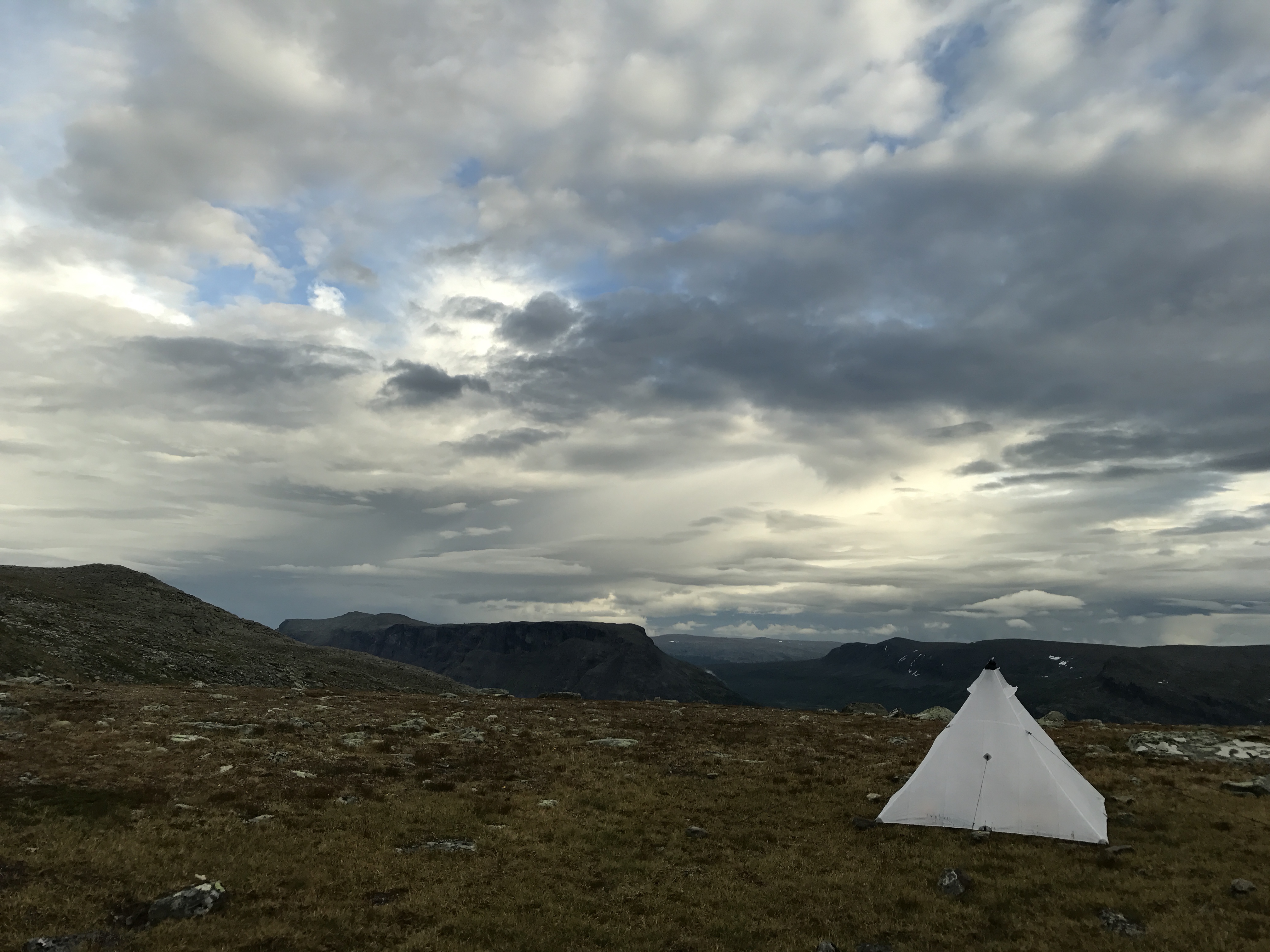
The gravel road was narrow, with steep sides and sheep both here and there so I had to drive slow. It was a welcomed sight when I came to the parking lot near Middalsbu. I had thought about sleeping in the car, but I still wanted to get a night in the tent. So sometime between 00:00 and 01:00 I hiked away from the parking lot to find a good place to set up the tent. I was going to go to the Middalsbu cabin, as I thought that there is flat dry ground there. It did, and by 01:40 I had gotten my camp up there.

I usually have trouble sleeping, but this night I passed out as soon as I laid my head on the pillow.

It was quite windy so I slept with the inner door open and the roof vent completely open, as there were no mosquitoes.

Monday

I woke up around 06:30 and got up to take a leak. The thought occurred to me to pack up, as there wasn’t any rain, but it would rain for the rest of the day. But I was too tired, and went back to sleep. I woke up from pouring rain, and occasionally from flies coming in, so I closed the inner door, but fell asleep again and slept until just before 10.00. I made breakfast in the vestibule and waited for the rain to blow over. Eventually it stopped completely. I wiped off the tent, and packed everything up.

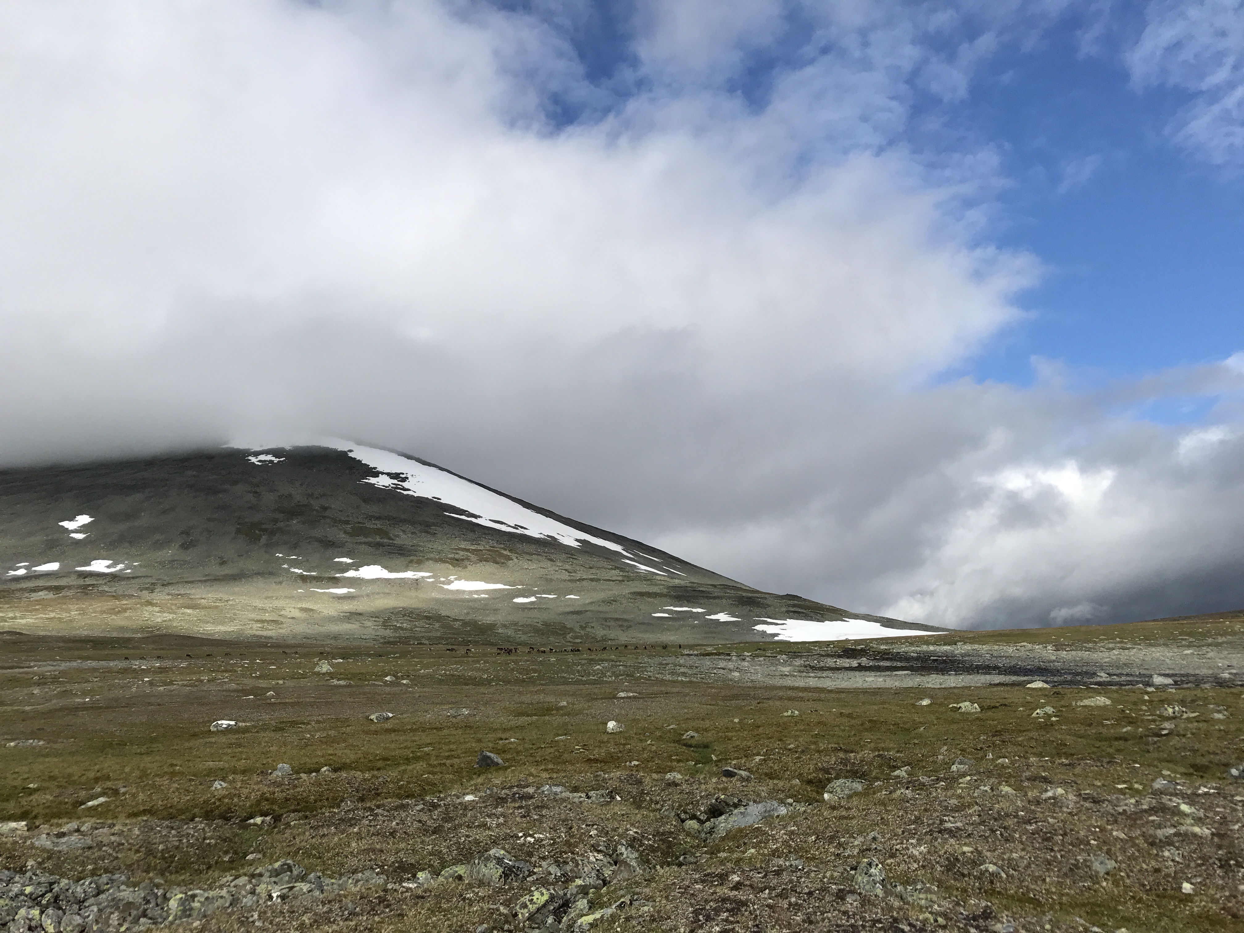
It was time to start hiking towards Hellevassbu. It was only a 16km stretch, but the map calculated that it would take 7h. A good sign that it was a tough passage. And that was it. I met 4 people who all said it was tough, and difficult to follow the trail in some parts. It began with almost 10 km uphill, it was raining, then the fog came. There was a lot of snow left and with the fog you could not see across many of the snowy passages, and therefore could not see the trail markings. You just had to guess the direction. I got more and more tired, tripping on the slippery rocks and in the snow, and questioning my life choices.

In the end I reached the top, and it was flat for a while before it went steeply downhill again. Due to the melting snow and rain, all the waterways were filled with water, and it was difficult to wade across.

I thought several times about stopping and setting up camp, but I still wanted to go all the way to Hellevassbu to be able to dry my clothes in the cabin. It’s no fun putting soaking wet clothes in the tent and making everything damp.

Once I approached the cabin, I felt the wonderful smell of smoke. A sign that the heat was running in the cabin.

I took off my backpack by the cabin, walked away a bit and set up the tent and then went into the cabin, which was packed full with people. I hung up the rain gear, socks and shoes to dry in the overcrowded drying room. I had originally planned to eat by the tent, but there were a lot of mosquitoes there, so I decided to eat in the cabin while the clothes dried. There were a lot of people in the cabin, and I talked to some young Norwegian guys and to a German retired couple who were experienced hikers. The couple had set up the tent on the same peninsula where I had my tent.

Shortly after 21.00, my clothes were dry enough, and I left the cabin to lie down in the tent.

It had started raining again, and I hurried into the tent, unpacked everything and prepared the sleeping gear. I texted my wife goodnight on inReach and lay down to fall asleep to the sound of the rain pattering against the tent fly.

Tuesday

I didn’t sleep as deeply as the night before, and got up to pee during the night. I woke up around 08-08.30 but stayed a bit under my quilt before having enough energy to get up.

I made breakfast, coffee and tortilla bread with cheese and sausage. It was sunny, and at that moment it felt very nice to be in the mountains. Something that would change over the course of the day.

I had the camp near the cabin, and I saw how several people were already done and hiked away when I had my breakfast. There was some condensation on the tent, so I prepared the fishing rod and threw a few casts while waiting for it to dry up a bit. When I was younger I did a bit of fishing, but I was always bad at it. Last fall though, me and C started fishing together and it really sparked my interest. This was the first time I brought fishing gear to the mountains, and I had hoped to catch trout for the first time in my life.

After the tent had dried up a bit, I wiped off the last of the moisture on the tent and packed up the camp. My goal for the day was the mountainstation Litlos.

The German couple finished packing up at the same time as me, and we walked together towards the cabin. They were also going to go to Litlos, but stayed at the Hellevassbu a bit longer.

The Germans and I passed each other several times. When I paused, they passed me, and when they paused, I passed them. The weather was OK, and it felt great to be in the mountains, but hard to hike. My body was still sore from the day before.

I started walking towards Litlos, and it was a lot of uphill in the beginning. The sun had disappeared, but there wasn’t any rain. I had downloaded the weather report with my inReach in the morning, and it showed that the rain would come in at around 14.00.

Around 12:00 it started to rain. In the beginning it was not a downpour, but only a light rain. I had planned to eat at 13.00 and made the moronic choice to sit behind a rock in the rain and cook at 13.00 since that was my plan. Not just boiling water for a freeze dried meal, but frying bacon and cooking macaroni. It started raining more and more. Heavy drops and wind driven rain. I sat on a slope so the water ran along the cellfoam mat down to my butt. I would then discover that I had a 1,5 dm long tear in my crotch on my rain pants. I would also later discover that the water proof membrane was torn to shreds. The Germans passed me, and also another couple with 2 dogs who’d been camping just next to the cabin the night before.

I sat there behind the rock, cursing myself for deciding to cook in the foul weather, while my legs just got wetter and wetter. The rain jacket is good, but the rain pants were in worse condition than I thought. The lamination was torn, and now also a long tear in the crotch. They were rain pants by name only.

After dinner, I swore long tirades and packed up. I wandered with my aim set for Litlos, where I intended to dry up. I had first planned to continue the next day to Hadlaskard, but with the second day in veritable crap weather I was already getting tired of it. My upper body was dry, but my whole lower body was totally soaked and cold. I made my way across streams, paths turned into streams by the rain, and over blankets of snow.

I crossed some bridges. At a crossing with two bridges, a bunch of sheep crossed them. But at the second bridge, two sheep decided to be a little bit cooler than the rest, and go through the rapids instead, while the rest of the herd walked on the bridge above them. The rapids caught them, and I thought they would be done fore, but they did manage to get over safely to the other side.

When I finally saw Litlos, it was a wonderful feeling. I still swore and was angry with myself that I had gone here to Hardangervidda instead of canoeing in the warm and sunny southern Sweden, and that I could be lying in the hammock on an island in the sun and relaxing instead. Even though I saw Litlos from far away it felt like an eternity to get there, as it was on the other side of a lake, which I had to walk around.

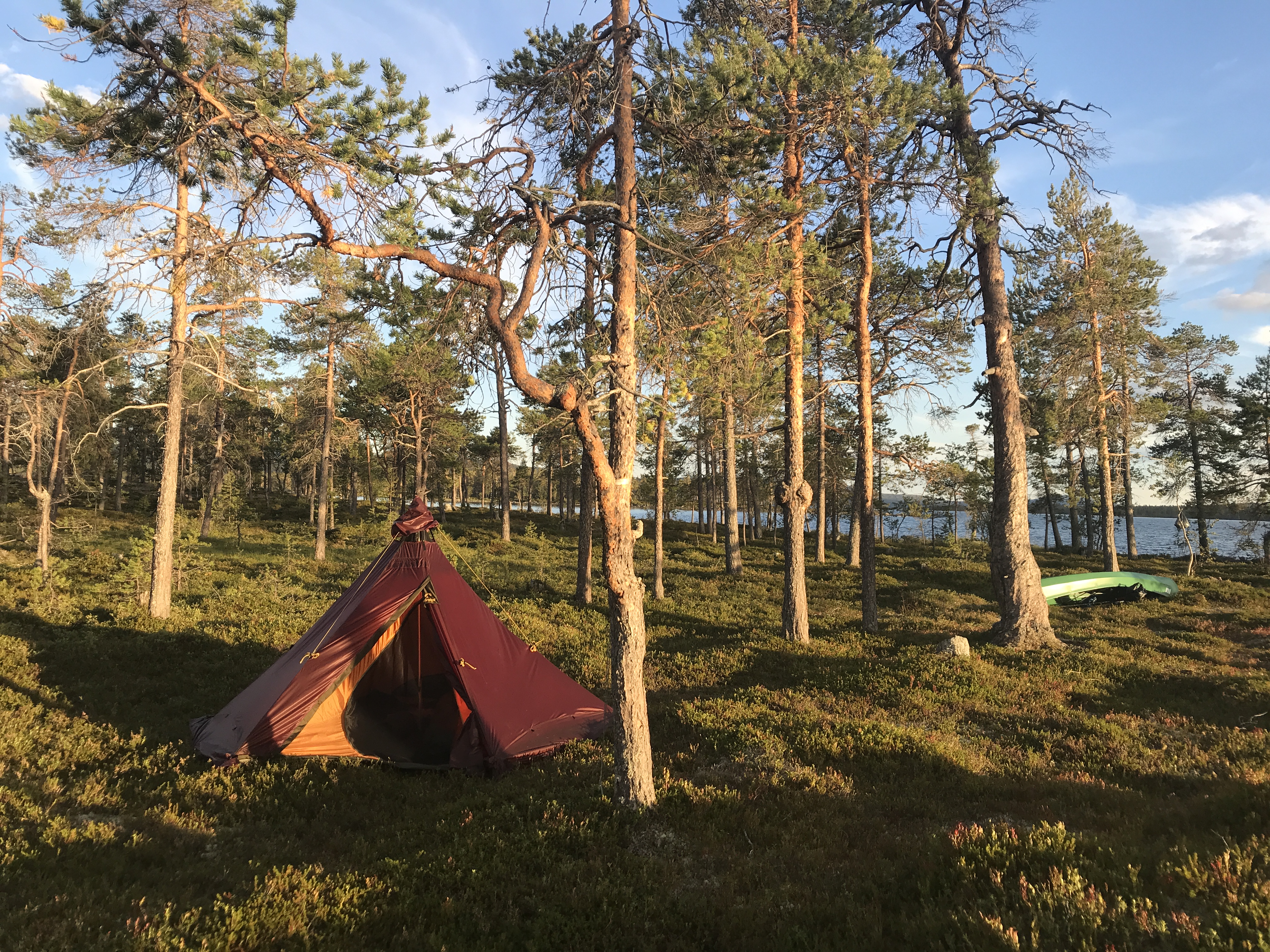
About a km from Litlos I stopped to pitch the tent and put most of the gear in it. I brought some food, a book and water in my backpack and walked the last bit to Litlos.

I was shaking from being cold and wet. I went to the overcrowded drying room, where I hung up everything that was wet (which was everything). I started talking to a Norwegian guy who had been fishing during the day, and caught three big trout. He was completely ecstatic as it was his first time. We went into the main cabin, which was a manned cabin, bought beers and continued talking. He, like me, had fished sporadically in childhood, but a year ago he bought equipment and re-sparked his interest. It was the first time he got trout and he was in a great mood. He was going to sleep in a tent near the cabin that night, but had slept in the cabin the night before. He told me that a couple had celebrated their wedding anniversary in the next room, and he said they had physically “celebrated” through half the night, before they finally quieted down enough for him to be able to sleep. A young Norwegian couple sat down next to us and we continued talking. They would have dinner in the cabin. I had originally intended to eat a freeze-dried meal, but went and ordered dinner after talking to them. A three-course meal cost 560NOK, so I only took the main course for 260NOK. I was the only one doing it, so I felt ridiculous at first, as I sat with my water glass while everyone else ate their starters.

After dinner, I went to check on my clothes. There I met a UL-hiker from Denmark, and we started talking about equipment. My clothes were far from dry, but at least it was better than before. There was a break in the rain, which would soon return, so I took the opportunity to pack up and walk towards the tent. The wind was very strong. One person at the mountain station had talked about 20m/s, but I don’t know how accurate that was.

I came back to the tent, put up the sleeping mat and the quilt, put on a dry base layer and crawled under the quilt. The rain and wind increased again. My body ached and I was so happy to lie down and go to  sleep. During the night, the wind and rain increased even more, but I felt confident that the tent could handle it without any problems, and went back to sleep.

Wednesday

I woke up to a sunny day, and it was hot in the tent. It was a wonderful feeling after yesterday’s cold and wet experience. I really just wanted to lie in the tent and relax all morning, but I knew that it would likely only be nice weather in the morning, as the weather report showed rain later during the day. When I opened the tent, I saw a couple walking by. It was only 08.00, but they were already on their way.

I made breakfast and packed up my things. By 08.50, I was on my way. It felt great to walk in the sun. I stared to love hiking again, after having quite the opposite feeling about it the day before. I wasn’t going to go far today though. My plan was to hike back towards Middalsbu via Vivassdalen, and take two days for that streach, setting up camp early and spending the days fishing in the lakes along the way.

The rain, which was supposed to come at 14.00, came already at 10.30. But by then I was already at the southern end of the valley where I had planned to set up the tent. I stopped there and set up camp. When I crawled into the tent, the rain got a lot worse. It was nice to be inside the tent this time, and not having to hike through it with my torn rainpants. I waited out the rain, which lasted for an hour, until the sun came back out. I took the opportunity to prepare the fishing gear.

I went down to the lake and threw a few casts. It was shallow. I started with a Toby trout lure, then a pink Vibrax spinner, my designed jig from Kanalgratis, and then back to a Toby. But I just caught seaweed. I wasn’t sure if there even were fish in the lake, or if it was shallow enough to freeze through in the winter. I threw some more, but then headed back to the tent to make lunch. I made bacon with macaroni and parmesan. When the food started to get ready, it started to get windy and rainy again. I closed down the tent and ate my lunch snug an secured inside. After that, I laid and read for a while. The weather switched between rain and sun, but the rain came so often that it was not worth going fishing. I also took the opportunity to tape the tear on my rain pants with duct tape. They would still be bad, but at least provide protection for a little longer than otherwise.

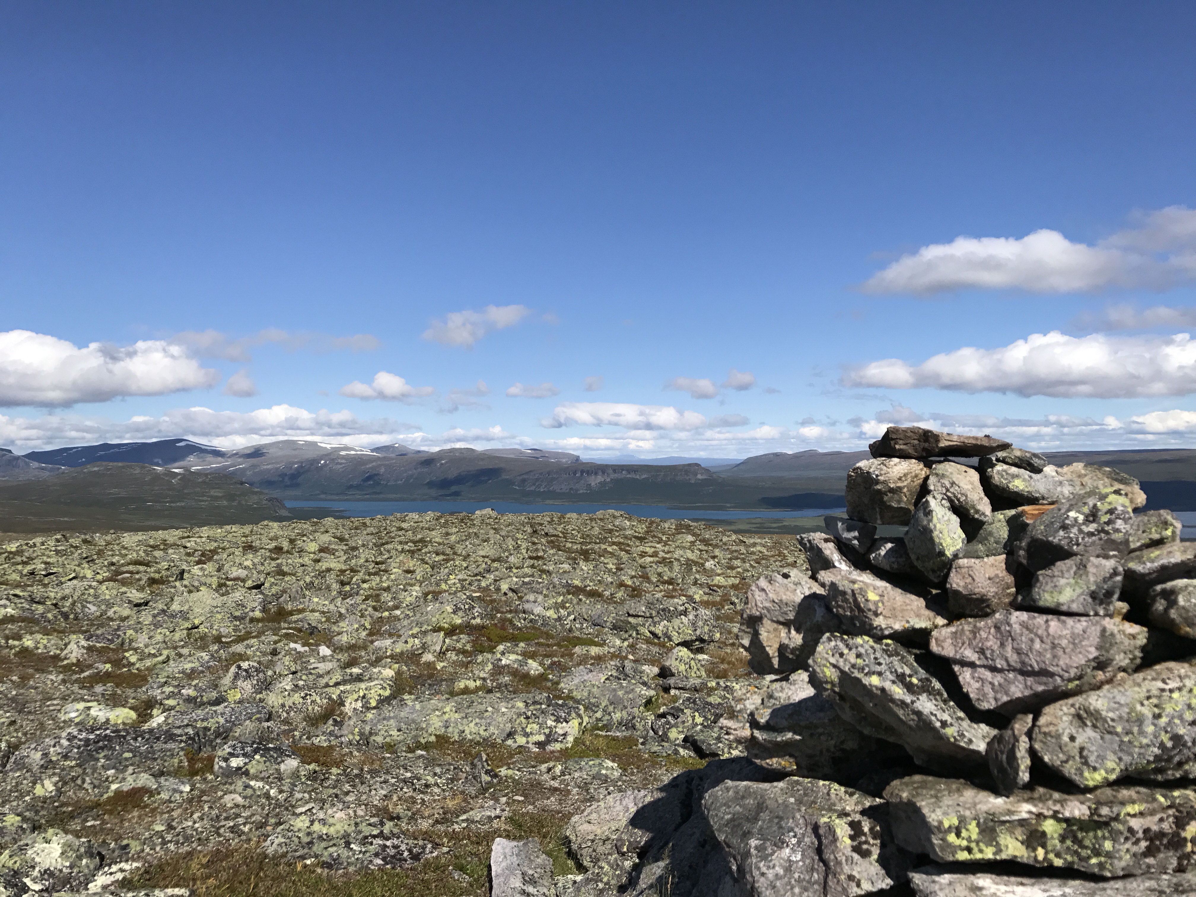
I stayed in the tent for a while to read, but finally got out, since I wanted to get up on a peak that was behind the tent. I begun to get up, but it started to drizzle and really dark clouds were coming in. I had the rain gear in my bag, but still didn’t want to risk getting soaked when everything finally started to dry up. I went back and hunkered down in the tent, but no downpour came, and when the sky looked pretty clear again, I begun my ascent. The peak I was aiming for was too hard to reach though, so I choose another peak instead. The view was amazing. I also got a good view of the lake, and saw a spot where I thought it would be nice fishing. I admired the view for a while, and then went back down.

At the tent, I made a snack, and then took the fishing gear out to try my luck at the spot I saw from the top. I put on a dark copper Toby and began casting. On my second cast, I got a fish. A nice big trout, and the first one I’ve ever caught. I was ecstatic. I had said to myself that if I only get one trout on the whole trip, the fishing license I bought would be worth it. I saved the trout for dinner, and cast again. Immediately I caught a bite, but this time it was a small trout, so I released it again. One more throw, and another fish again. An even bigger trout than the first. I had to fight hard to get it in.

I had an adrenaline rush from the fishing, and I really like eating fish. It felt absolutely amazing to have caught my own dinner, which would taste a lot better than freeze dried meals. I didn’t cast any more after that, since I didn’t want to pull up more fish than I was going to eat that night.

I cleaned the fish at the edge of the lake, and just when I was done, dark clouds and wind rolled in. I ran in the drizzle towards the tent, and the rain started pouring down just in time for me to get inside.

Around 18.00, I decided to fry up one of the fishes. I planned to keep the second one for breakfast the next day. I fried it in butter and rapseed oil, and seasoned it with lemon pepper. It tasted amazing and I wanted more, so I fried up the second fish too.

I washed the dishes and laid down to do a bit of reading. It started to get cold and rainy again. At 20.00, I started to watch Star Trek on my phone, which was the only interesting thing downloaded on my Netflix app.

I texted my wife a bit on the inReach, and then laid down to go to sleep.

Thursday

At first I had trouble falling asleep, but in the morning I also had a hard time waking up. I woke up around 08:30, but had a very hard time getting started. It was cold, cloudy and drizzly outside. I put on my down jacket and made breakfast while I stayed under my quilt. When I finished breakfast and packed my sleeping gear, the rain started pouring. Since I wasn’t in a hurry I stayed in the tent a little more, to let the rain blow over, and to let the tent dry up a little before packing it down.

I started hiking. The route was flat, but very rocky with a steep side down to the lake. I slipped once and started sliding down towards the lake. There was snow and ice left in the lake. The weather, which started with a drizzle, turned to wind-driven freezing heavy rain again. I had been aiming for a lake to set up my next camp, and I didn’t want to pause in the bad weather. I thought I would get there faster than I did though. The weather was absolutely abysmal, and the taped up tear in the rain pants went up after only a few minutes. The rain pants soaked through in 30 minutes and then I was soaked and cold on my entire lower body. I felt dry on my upper body for a long time, but after several hours of heavy wind-driven rain, it turned out that the rain jacket had also wetted out and soaked through.

I am usually able to keep my temper, but several times I completely lost it in the horrendous weather. I hacked the hiking poles furiously in the ground and shouted curses at the mountains for dealing me such crappy weather.

My knees, especially the left one, began to ache from exertion and being cold and wet all the time. It just got worse and worse, and eventually I had to limp and drag myself on the hiking poles. I arrived at the lake where I was going to camp, and set up the tent.

I lay in the tent for a while. The rain stopped, the sun came and went, and I managed to dry up everything except shoes and socks. In the evening I limped to the lake to do some fishing. I thought the nearest place would be bad, and I only caught vegetation. I accidentally ripped off the line at one throw and lost my copper Toby. I went to a another place that looked good, and quickly caught a small trout. I released it and threw again. But the lure got stuck in a bush, the line was torn off, and I watched my silver Toby fly in a wide line out into the lake before disappearing under the surface.

I limped back towards the tent. The knee felt worse than ever, and without the hiking poles with me, it was a struggle to get back.

I laid in the tent for the rest of the evening, and finally fell asleep.

Friday

I had a little trouble falling asleep, but in the morning I slept like a log, and had to force myself to get up. I wanted to get started early, and had a quick breakfast before packing up camp. The weather was beautiful.

The knee was a little better, but still hurt. It was possible to walk if I walked with my leg straight and kind of threw it out with each step without bending the knee.

Near my campsite there was a strange cottage, which looked sort of like a Hobbit house. A young couple sat outside and invited me for coffee and chocolate. I declined a couple of times, but as they continued to insist, I accepted and had some coffee with them. It was a young Israeli couple that Air-BNB rented the cabin. They had arrived the night before. We sat and talked about all sorts of things for about half an hour before I moved on.

I managed to hike quite well, but when I was almost at the parking lot, my knee gave up completely. I had to drag myself down the last bit of the trail before I got to a flat road that was easier to walk on. I got to the car, looked at the beautiful but treacherous mountains, and packed up. It was a struggle to get my leg into the car, and it hurt to use the clutch, but it eased up after a while.

I drove for about an hour before making noodles for lunch at a rest area in the mountains. I also stopped at Heddal Stave church, which is a beautiful building.

My oldest daughter wrote that she preferred me to come home on Saturday instead, as she would have friends coming over. Since I wouldn’t arrive until around 01.00 anyway, I thought I’d pause on the way and spend one more night in a tent.

I didn’t find any good place when I searched my phone for it, but I wrote to an Instagram friend who’s camped a lot on the west coast for tips. She sent some links, and then I saw that Kosterhavet national park was close. I found a cape on the mainland that was part of the national park where you could camp. I went there, but the parking lot was 2.5km from the national park itself, and was instead in a nature reserve with a camping ban. I was a bit worried about how my knee would cope with the hike, but it went well and at the far end of the cape, just in time for a nice sunset, I found a perfect camping spot. I pitched the tent and felt happy to have such an end to the trip. From 6⁰ C and icy wind-driven rain to 20⁰ C, sunset over the sea and not a cloud in the sky. It felt like paradise.

I laid in the tent for a long time with the view of the setting sun and really enjoyed myself, on this last night of the trip.

It had been a strenuous trip, both physically and mentally. The weather made it more challenging than I thought, and the torn rainpants and busted knee made it even worse. But the last night at the beach, and the trouts I got made it all worth it.

Significant gear

(Disclaimer: Below list contains affiliate links, which means I get a small commission for purchases made through the links. The gear is bought with my own money though and I have not been asked to review the gear. Good lightweight gear can be bought from backpackinglight.se in Sweden, or backpackinglight.dk for international shoppers. It’s run by Kenneth Shaw, who blog at https://ultralightandcomfortable.com/ )

I’m really happy with my gear right now. I thought I’d find the Soulo too heavy, compared to a lot of tents I’ve tried earlier, but I really loved it. I feel confident that it’ll handle everything, which makes me sleep well in poor weather, and I like that the inner can be opened up fully. The quilt is amazing, and I’ll never go back to a 3-season sleeping bag.

Hilleberg Soulo (SE / INT)

Cumulus quilt 450 (SE / INT)

Hyperlite Mountain Gear Southwest 4400 (SE / INT)

Storminstove with Toaks UL 700ml pot (SE / INT)

Fulufjället national park – 3 day hike

Neither C nor my wife have been hiking in the mountains before. My wife likes daytrips, but aren’t too fond of the camping part. She still joins me and C from time to time though. And this year, with Covid stopping our usual trip to Athens we decided to go on a hiking trip in the mountains together. Our oldest daughter preferred to stay at home, and our son was away on camp. I had scouted different areas that would suit beginners that wasn’t several days of driving away. Fulufjället National park was 8-9h drive from home, and seemed to be a fairly easy hike. As always we do things spontaneously, and we didn’t decide that we would go hiking until a couple of days before going.

Info

Fulufjället national park is a mountain plateau situated in Dalarna in the southern parts of the mountain range, next to the Norwegian border. The park has the highest waterfall in Sweden, the 93m high Njupeskär waterfall. Here you can also find the worlds oldest tree, the 9565 year old spruce tree Old Tjikko.

There are several hiking routes, from 2-24km, but you can mix the different trails to a suiting route. The main entrance is at Njupeskär, where you also find Naturum. The park has different sections with different regulations. In most parts of the park you are allowed to camp, but not in the most frequently visited parts.

Trip report

Day 1

We packed the car the day before, and left home at around 04.00 in the morning. Without breaks, it would be an 8-9h drive and we wanted to get there early enough to reach the plateau in the first evening. I had made an own route that would be some 24 km hike, and I expected us to spend three nights in the tent. In the end we only did two nights, since C hiked on in a better pace than we expected. At the end she would be the one with the most energy left.

I didn’t want to start at Njupeskär, since I expected it to be very crowded now that a lot of people where going on Swecations. Instead we would start at entrance at Brottbäcksstugan, south of Njupeskär, hike west to Särnmanskojan, then south to Tangsjöstugan, east to Göljåstugan and then back north, past Klotjärn and back to the car at Brottbäcksstugan. We were not going to use the cabins, but I wanted a route were we would pass cabins and privys every day, to have the option of a little more luxary if we would get tired of camping.

I really looked forward to the trip. I’ve wanted to bring C to the mountains for a long time, and I had really missed them myself. I haven’t been hiking in the mountains since 2017.

We arrived at Brottbäcksstugan around 15.00 and prepared for the hike. There were a few cars on the parking lot, and in the distant I could see the mountains. The first sections went through a forest, but the trail soon turned uphills and the trees became smaller and more scattered. The sides of the mountain plateau is fairly steep, and it didn’t take long for us to get up above the tree line. The views where amazing. It wasn’t the tall sharp snow covered peaks of Jotunheimen or Sarek, but soft and rounded tops. But it was mountains and vast views, and I had really missed that. I felt a rush of joy to be back in the mountains, and I was really happy that I could share it with my family.

Going up
Coming up above the tree line

It took an hour to reach the plateau, and once we reached it the wind kicked in. I didn’t know how far C would want to hike, so I started to look for potential camps sites pretty soon. The ground was very uneven with lots of wet parts, so finding good spots for a large tent wasn’t easy. But I did find a few spots that I marked on the GPS for potential future trips.

But we kept hiking, as both C and Maria wanted to keep going, and eventually we reached Särnmanskojan. It just an emergency shelter, but there where a few people there. It’s also an intersection for several trails, and as we had our break there a lot more people passed and a few of them stopped to set up camp around the cabin.

We considered setting up camp near the cabin, but Maria wanted to keep going after our break. So after a short rest with snacks and a visit to the privy we turned south and started to hike towards Tangsjöstugan.

Near a few ponds, over a small ridge a bit away from the trail we found a nice flat spot for our tent. There were another couple in a tent across the pond/lake, but we didn’t want to go any further and risk not finding a good spot before nightfall. A mistake I made so many times before.

C:s teddy – Ninja Nalle
Our camp on the first night

I gathered rocks to anchor the pegs, since the soil layer was thin and it was hard to get good grip. The pitch was terrible though, but I didn’t see it that night for some reason. The fly flapped like crazy all night. I fixed it in the morning though, just for practice.

When the tent was up we made dinner, and then we just hung out in the tent before going to sleep. I got up once in the middle of the night, and despite not being extremely far north it was still fairly bright outside.

Day 2

After waking up I saw how bad my pitch was, and tightened everything up just for practice. I had only used the Ultamid 4 a couple of times before, and I thought it would be good to work on my weak spots when it comes to pitching.

Ready to head out
A well deserved break

I made Krabbelurer for breakfast and then we packed up. We continued hiking south towards Tangsjöstugan, with a few breaks here and there on the way. C would loose her energy every now and then, but as soon as we started to play something while we hiked she went on like she would never stop. At lunchtime we arrived to Tangsjöstugan. No one was there, and we explored the cabins. It was really nice and I can imagine what a welcome sight it must be for someone coming in from a storm.

Tangsjöstugorna

We made dinner, and several groups came passing by or stopping for breaks. We chatted a bit with a German couple that had hiked for 2 weeks I think, that were heading north.

After the lunch break we turned east towards Göljåstugan, another emergency cabin. We took frequent breaks, and me and Maria was starting to get more tired than C. We thought about stopping sooner, but still wanted to go to the cabin.

Leaving Tangsjöstugorna

The cabin was at a height near a gorge and the view was stunning. There where good places for the tent nearby and we decided to stop. Maria wanted to continue at first, but I thought it was better to camp out there than to try to push our selfs to the limit. We had done calculations on both the map and the GPS, and come to the conclusion that we should be able to reach the car the next day.

Closing in on the gorge for our second camp

I had been starting to feel ill. I’ve had some fluctuating health issues with stomach aches and frequent infections since a year back, and it had started to act up on the drive to Fulufjället. During the second day I was starting to feel worse and it was a bit hard to fully enjoy the trip.

But dropping the backpack and making camp felt wonderful. And this time I got a drum tight pitch of the tent (unfortunately we didn’t have the slightest wind that night).

View from our camp
The Ultamid 4 is a roomy temporary home
A beautiful sunset with the Ultamid 4

We made dinner and chillaxed in the tent. The mosquitoes where abundant so having the roomy full inner of the Ultamid 4 was wonderful. We kept the doors of the fly open until it was time to go to sleep, to enjoy the view.

Day 3

The next morning we packed up and headed out. We had studied the map, and knew that the first section would go through vegetation, and then through a sea of boulders. We would also have a river crossing further on. The sign showed a longer distance back to the car than we had measured on the map and GPS, but with our remeasures we still got the same shorter distance. We hoped it would be okey to hike all the way back to the car without straining our selfs.

Time for breakfast

After the boulders we came up on the plateau again, before heading back down into another gorge. The river was pretty wide, and split up in two with an island in the middle, so we would have to do two crossings to get over.

The second gorge

C had been a champion this whole trip, but the crossing the river really scared her. There were fairly large waterfalls both above and below us. “I can’t do it! I’ll break! I’ll break like a twig!” But she did it. After spending some time persuading her she would let me help her get over. Unfortunately though the got one boot in the water and filled it. She was scared when we came to the last crossing, even though that crossing was a lot easier. But after a while she came over.

The first crossing. It was deeper and wider than it looks

We came up from the gorge and took a break after a while. A German woman came from the opposite direction and stopped for a chat. She asked if we had Compeed, since she was getting blisters. She had left hers in her tent, and was only going for a day hike from her camp. She got a couple from us, and continued south.

Our last stretch above the tree line

The trail started to go downhill for us, and we came down below the tree line. And now we had mosquito paradise. They where out in full force as soon as we stopped. I was getting worse and worse and it really took its toll, and I could barley eat. C was the one who were in the best mood. We regularly measured the distance om the map to the car and understood that we would make it back in a descent time. As we got closer we also got cell reception and I started calling hostels nearby to find a room for us for the night. Neither one of us longed for another night in the tent with a freeze dried meal.

Mosquito paradise below the tree line

We stopped at Klotjärn for lunch and from there I could find a room in a hostel at Särna Camping after calling around to several other places closer to Fulufjället. In the end I think we hit the jackpot in getting there since the food and the staff was amazing.

After booking the room we hiked the last stretch back to the car. In the car we had a bag of vanilla buns in a cooler. And they tasted better than vanilla buns ever tasted before. The bag didn’t last long.

We sat in the car and drove to Särna and the hostel. We checked in, took showers, changed clothes and went down to the restaurant to eat dinner.

I might have had some prejudges against campings and the kind of food they’ll serve. But this camping really ended that prejudiced. They had all sorts of local specialties, with moose, reindeer, local fish and local beer. When we came down to the restaurant we could hear another couple praise the food and exclaim how it exceeded everything they could have expected. As the burger lovers we are we ordered burgers and the local beer Härjebrygd. The food was amazing, and I don’t think it was solely because we had eaten freeze dried meals the days before. We had a dessert of Kolarbotten. Vanilla ice cream with kolbulle (a sort of fried bread), Messmör caramel sause and fried pork. It sounded so weird we just had to try it. But it tasted so good. The waitress came back after a short while, looked at the empty bowl, smiled and asked C: “Did you get to taste anything, or did your patents just devour everything?”

This felt like a wee deserved meal

The hostel was situated next to Klarälven, one of the largest rivers in Sweden, and there was a nice little peninsula with a beach. We had fantastic weather and after dinner we strolled along the beach while C played in the water line.

Freshly showered and fed

We were tired, and as it was getting late we wanted to go to bed. C however wasn’t tired despite hiking 24km. “I’m still so full of energy” she exclaimed, so I stayed up with her a little longer so she could play at the play ground.

We aren’t sponsored or anything by Särna Camping, but I really have to give them a shout out. The food was great and the staff really was super friendly and welcoming.

Day 4

Njupeskär water fall

We had decided to skip Old Tjikko, but still visit Njupeskär waterfall on this last day. We’d had wonderful weather our whole hike but this morning we woke up to torrential rain. We had our packed up, left the hostel and drove to the main entrance. Despite the rain there were already a lot of people there.(a couple of weeks later the lines would stretch several kilometers). We did consider turning back, but since we were here we wanted to see the water fall. A long portion of the 3.9km round trail is accessible with a wheel chair.

Torrential rain on this hike
Njupeskär water fall

After a while we reached the water fall, took a few photos and then headed back to the car. On the parking lot we met a group that was on their way to the water fall and they asked us if it was worth hiking there in the rain. We didn’t really know what to answer as we were wondering that our selfs.

My expensive Montane Minimus jacket had kept me mostly dry except for a few wet spots. My cheapo rain pants though had wetted through completely and I felt like I could as well have gone without them. After the trip to the water fall we headed back home, and spent the rest of the day in the car.

I’ll write about the gear we used on the trip in a separate post.

Canoe camping for a week on Isteren i Norway

I had planned to do to a week-long trip in mid August, but I had been going back and forth a lot about where to go – hiking in Hardagervidda or canoeing in or near Femundsmarka.

Eventually I decided to do a week long paddling trip on Isteren, a lake near Femundsmarka National Park in Norway. My plan was to park at Glotbergen, in the southern end of the lake, and then paddle north and just see where I’d end up, without any specific goals.

Day 1 – Saturday

On Friday evening I packed everything after I got off from work. I packed all the gear in my backpack, and had a separate heavy duty drybag for my food. Since I was going canoe camping, I had a lot of heavier foods, like portion packed orange juice boxes, canned chicken etc.

Earlier that week I had also purchased a Bergans Ally canoe. A foldable canoe that fits in the trunk of a car, and is made of a frame of aluminum stays, covered with a durable rubber hull. I had made a test set-up in the backyard, but I hadn’t paddled it yet.

Glotbergen was a 700km drive from home, so I wanted to start early. I set my alarm clock to 03.45, and by 04.05 I was on my way. This would be my first longer canoe camping trip, and my first week long trip alone. I was excited.

I arrived at Glotbergen at 13.00, where I paid for parking and for a one week fishing permit. The drive up to Glotbergen was pretty dull, and I can’t wait for self driving cars to be the standard.

I assembled the canoe in 30 minutes. The first time I had tried it, it had taken over an hour. I loaded the canoe with the gear in the front, strapped it to the canoe, and set off. I was finally on my way.

20180811_121045955_iOS

Water levels where low, and I soon hit a rock with the canoe. I could see traces of aluminum on the rock, which showed that I wasn’t the first one hitting the rock. This would be something I would see on rocks for the rest of the week.

Since I had been up very early, and hadn’t gotten much sleep the night before, I decided to set up camp as soon as I found a nice spot. I paddled for 1,5km when I spotted a nice sandy beach, where I landed the canoe. There where traces of camp fires and make shift fire rings all over the place. For now there was a fire ban, but fortunately, that didn’t include camp stoves.

20180811_165146221_iOS

I hiked away from the beach, and found a nice place to set up my tent. I carried my gear and the canoe there, at set up camp. The rain came soon after I had my tent up and I laid in the tent, listening to the sound of the raindrops hitting the fly. The rain soon stopped though and the clouds scattered, and the rest of the evening I tried fishing for a while, and just relaxed in camp. I went to bed early, happy to be out in the wild.

Day 2 – Sunday

When I woke up, the weather was worse than the day before. Skies where gray, and it was windy. The weather report showed winds of up to 7 mps, and of course it was head wind. My goal was to paddle to Steinsundsholmene, a group of small islands, a mere 3 km north of my camp, and after breakfast I set off.

Initially I had loved the portability and pack-ability of the canoe. The low water levels meant that most shores where covered with large sharp boulders, and the canoe had to be carried up on land so that the waves wouldn’t bash the canoe against the rocks. But now I learned about the downsides of this type of canoe. The softness of the hull makes it pretty slow in the water, and the light weight and construction makes it float very high up in the water. This makes it easy for the wind to grab a hold of it, to turn it around. Every gust tried to swing the canoe around, and I had to struggle like crazy just to keep is straight in the water. It was a really slow going, and I got in a pretty bad mood, and cursed my decision to buy it.

Eventually I gave up, took it to shore and decided to portage it north instead. But this proved to be difficult too, as the terrain of large boulders made it hard to pass with the canoe. I sat on a cape for a while, reviewing my options, and wondered why the hell I hadn’t gone hiking in Hardangervidda instead. I decided to put the canoe back in the water and just paddle like a maniac.

20180812_132257162_iOS

I eventually reached the islands, and set up camp on a cape in the mainland. I wanted to hike up to the nearby mountaintop Bottölen the next day.

20180812_180603731_iOS

The campsite was beautiful, and had a great place for my tent. I fished for a while, and soon a big perch bit my little spinner. I’m not really a fisher man, so it was the biggest perch I had ever caught (which doesn’t say much really). As soon as I got it close to shore it got off my hook though, and swam away.

20180812_180731541_iOS

The winds had calmed down and the clouds had scettered, and by the evening the weather was really beautiful. I put the canoe back in the water and paddled around for a while. Paddling in calm waters is really nice and relaxing, and now I was glad to have chosen a canoe camping trip. I put my hammock up, and had a nice calm evening.

Day 3 – Monday

I had decided to stay two nights at my campsite, since it was a great location, and also because I wanted to do a day hike to the nearest mountain top – Bottölen. Bottölen is only 905 meters above sea level, but it’s still above the treeline.

After having breakfast I packed my backpack with food, water and cooking utensils, took my map, set a course on my compass and headed out. Just as I left three canoes full of people passed my camp.

20180813_090051530_iOS20180813_100214303_iOS

I bushwhacked through the forest in a steady uphill. The top was only a little more than 2km from camp, but it was still enough for me to break out a sweat. There was a small mire between my camp and the top, and I hiked south of it, to avoid getting my feet wet.

20180813_101521776_iOS

Soon enough I reached the treeline, and despite the pretty low altitude, I had a nice view over the surrounding area. I kept hiking up, and eventually reached the top. The view was great, but I had to change my plans about dinner on the top. The winds blew too hard, so after a few photos and admiring the view, I started to hike back down, to make lunch at a more sheltered place. I had lunch at the mountain side, and then continued back to my camp.

20180813_102933632_iOS

The rest of the day I just relaxed in camp, hung out in the hammock, fished and paddled around the area. Paddling the canoe in calm waters is really nice. The campsite was great, and I really enjoyed staying there.

20180813_162255793_iOS

Day 4 – Tuesday

The next day I had decided to keep paddling north. I didn’t have any specific goal in mind, but more or less planned to paddle until I found a nice place and then stay there. There where almost no wind when I set out, and the lake was still as a black mirror. It was a really nice way to start the morning. I paddled slowly north, and really enjoyed the morning. After a while I stopped at a cove, heated up some water and washed my t-shirt and underwear in a zip-lock bag, before I continued again.

20180814_082205277_iOS

I reached Nysandvika, where there were a lot of tents and canoes. I saw a family take down two HMG Ultamids. It was the first time I’ve seen anyone else use cottage gear in real life.

20180814_094531909_iOS

I paddled around the cape and then came ashore at the northern side of Nysandvika. The cape had beautiful beaches with white sand, but the water was cold. I took a short break, had some coffee and then set off again.

I followed the shoreline up to the cove Langvika, where I stopped again at a small beach. There where a small hut nearby, and no place for a tent, so after reviewing the map a bit I continued. I had decided to explore the island just west of Langvika and check for descent camp sites.

I paddled to the westernmost side if the island, and found a great place for my tent. It was only 14.00, but I decided to stay there. Signs of previous campers where everywhere around that part of the island. This was great, and I decided that I would stay here for two nights. I had my camp, and my hammock up, and explored the rest of the island on foot.

20180814_180647554_iOS.jpg

The island wasn’t large, but on western side there where good places for tents on both the northern and the southern end. There where fire rings on both sides, and flat grounds for tents. The rest of the island was covered in blueberry- and lingonberry bushes. It had been a great day of paddling with perfect weather, and the little over 5 km of paddling had been easy.

Day 5 – Wednesday

I had planned to keep my camp on the island, and then paddle north with just my food and cooking utensils this day. But I woke up to a windy cloudy day. I paddled almost 1 km north in the morning, just to try the waters, and had a hard time paddling back to the island. I decided to stay there instead, reading, watching Netflix and foraging.

I filled my foldable Kuksa with lingonberries and blueberries, and then went to the shore to do some fishing. I had tried to catch a fish now and then during the entire trip, but it’s not such a big interest of mine. But now I got one, after just a few throws. It was another perch, and the largest one I’ve seen. I was happy to have caught one, since I was really looking forward to spice up the diet with some fresh fish.

20180815_115604476_iOS

I filed it on a rock and then fried it in tons of butter and olive oil, sprinkled with citrus pepper. It tasted great, and I had the cup of blueberries and lingonberries as desert.

20180815_123053707_iOS

The rest of the day carried on in a slow manner. Rain came and went, and I spent most of the time reading the book “Idag ska vi inte dö” (We shall not die today), a documentary about the journalist Magnus Falkehed and photographer Niclas Hammarström who got kidnapped in Syria in 2013. The whole trip was just loosely planned, and I liked the calm serenity of camp life.

I went through my plans for the end of the trip. I was going to paddle back to my first campsite, 1 km from the parking lot on Thursday, and then paddle the last stretch on Friday morning. The weather report didn’t look too good though, as the winds for the rest of the week where supposed to be headwinds of 7-10 meters per second (15-22 mph).

Day 6 – Thursday

I woke up on Thursday morning, and just as the weather report had said, the wind blew hard. I knew I would have a hard day of paddling ahead of me. 7km in hard head wind. I had planned a route where I would paddle from island to island, cape to cape, to get protection from the winds and a chance for some rest. Just 30 seconds of rest in the open water could mean being pushed back really far.

I left the island and paddled alongside it, protected from the winds. But as soon as I left it for open waters the struggle was on. The waves had white foam on them, and I had to work really hard to get to the closest island. Waves where up to the gunwales of the canoe, but the waves weren’t the issue. The gusts where. I had to struggle hard to keep the canoe straight. No J-stroke could compensate the wind, that felt like it came from everywhere. I had to switch sides with the paddle all the time.

20180816_075106829_iOS.jpg

I reached one of the closest islands, rested a while for it and looked towards Nysandvika, my next objective. The gusts felt like they where trying to knock me over.

I tried to paddle straight towards Nysandvika, but the wind pushed me more and more east, towards the shore. Eventually I reached Nysandvika, and landed on the northern shore. Today there was only one tent there, with two people and a canoe.

I carried my gear and the canoe over to the southern side. Waters where choppy, to say the least. I thought about calling it quits, stay there and then try to continue the next day. But the weather wasn’t going to improve, so I decided to just give it a go, and hope for the best.

I set off again, but the wind blew harder on this side of Nysandvika. I struggled a lot. On one section I could see the same rock next to me for more than 10 minutes while I paddled like crazy without going forward.

I reached Steinsundholmene where I had a short relive in the wind, before I continued. The closer I got to the beach near Sundholmen, where I would camp, the harder it was to paddle. The wind threw the canoe up against the rocky shore, and pinned it between two rocks, and the waves continued to bash it against the boulders. I kept going for little while more, but halv a km from the camp site I threw in the towel and portaged the last stretch. Winds would increase during the night, and the rain had been pouring down, so I set up the tent immediately, took out food that didn’t need any cooking and laid in my tent for the rest of the evening. There had been a lot of cursing this day, and I was really tired.

20180816_125853190_iOS

The weather report showed a break in the winds between 04.00-07.00, where winds would go down to 1-2 meters per second. I set the alarm clock to 05.00, and prepared to go to sleep early.

Day 7 – Friday

Trying to go to sleep early didn’t work. I tossed and turned throughout the night. The winds got worse, and relentlessly shocked the tent. At around 02.00 it finally calmed down. I had dozed off for about one and a half hour, but now I couldn’t get back to sleep. Eventually I gave up. I always have trouble sleeping when I’ve set the alarm clock very early, and little after 04.00 I started to pack up my gear. The canoe had been upside down, but the winds had knocked it over, and the interior was filled with water and debris.

The weather was calm, with only a slight wind. Sun wouldn’t be up until 05.20, but it was still bright enough to paddle at 04.40, when I left the beach, and my last campsite. It was nice to paddle in calm waters, with silent J-strokes and the red stripes in the horizon, showing that the sun would soon be up.

20180817_025904938_iOS.jpg

I paddled up to the parking lot, unpacked the canoe and disassembled it. A 5-point wash with wet wipes and a change of clothes, and I felt like a new man. 9 hours later I was back home.

I’ve had ups and downs this trip. It was nice to be out for a week, and not really have any plans but to just wing it. But I didn’t meet anyone for a week, and it got a bit lonely in the end.

In retrospect I don’t think I’ll do a canoe trip like this on such a large lake again. The nearby mountains and the open lake makes it very windy, and this canoe isn’t really meant for that. With the canoe a lot of nice desolate places nearby opens up too, so I can get a wilderness feel without having to drive 9 hours. Next year I’ll probably hike in the mountains instead, and do canoe trips on the smaller, narrower lakes closer to home.

Tresticklan – first trip of 2018

For a few years now I’ve had a tradition to go on a hiking-/ camping trip the first week of the year.

This time I had planned to do a two-night trip, and I really wanted to go to Tresticklan National Park as I really like the place, and hadn’t been there since May 2016.

Tresticklan is a ~29km2 National Park in Dalsland, just at the border of Norway. Together with Lundsneset nature reserve on the Norwegian side you have 55km2 of protected lands. The area consists of rift valleys, with vast pine forests, small lakes and ponds and bogs.

I have been in Tresticklan and Lundsneset two times before, and if you like solitude this is the place for you. It’s far away from any larger towns. The closest town is Ed, 15 km south of Tresticklan, with just under 3000 inhabitants. Apart from the occasional airplane passing by, you don’t hear any man made sounds. Being far away from towns also means that there aren’t that many visitors, at least in my experience.

I had taken a few days off from work, left the youngest kids at my parents and in laws so that my wife wouldn’t be left alone with the young tornadoes but also get some lone time, and left home early on Thursday morning.

The weather changed between rain, sleet and snow, and it was a 6 hour drive to get there. I can’t say I enjoy having to drive so far alone, and I can’t wait for self driving cars to be common (and affordable).

I got up to Tresticklan around 14.00. There was a small uphill from the main road to the road leading to the parking lot. The uphill was covered in ice, and my car slid down on the main road again. But with enough gas, and having the left wheels a bit in the ditch, I could get enough grip to get up the hill. The road wasn’t plowed though, and I almost ended up in the ditch a couple of times, even though I drove carefully.

When I came to the parking lot my car was the only one there. It was cloudy and snowing, and there was quite a lot of snow on the ground. The temperature was just below freezing, so the snow was quite wet. I put on my rain gear before I left the parking lot.

I knew from my earlier trips that it’s hard to find campsites for tents here. The rift valleys makes it hard to find level ground, and when you do, the ground is often to shallow to peg a tent, with rocks just underneith.

I hiked the trail west towards Lundsneset, and then turned south on western end of the circle trail in the middle of the park. I had camped here during my last trip, but I couldn’t find the location in the snow. I lost track of the trail several times, since it was covered in snow, and wet snow had stuck to the trees, covering the trail markings.

It was getting dark fast, and eventually I felt that I couldn’t keep hiking any longer, and had to set up camp somewhere. I left the trail and hiked straight up a hill, and found what looked like a somewhat flat place, with lots of undergrowth. I tried to compress the snow and the undergrowth to make it somewhat level, and set up the tent. It wasn’t level by any means. I had to put my sleeping pad in the wrong (shorter) direction in the tent, and stow my backpack and clothes under one side of the sleeping pad to make it level enough not to roll off it.

There was a heavy snow fall with wet snow, and I started to make dinner. I’ve seen one of the people I follow on Instagram bring premade rice porridge on her trips, and I had to try it, and brought it with me this time. I was a bit tired since I had barely slept the night before, and made just rice porridge and glüewine for dinner.

I had brought a twig stove with me. There is a fire ban in the park, but I had asked the authorities about it before the trip, and a twig stove was ok. But you’re not allowed to break any branches from neither living nor dead trees, which left me with already fallen twigs laying on the ground. Since everything was covered in wet snow I didn’t even bother. I used my gas canister stove, but since I had brought cheap gas it didn’t work well in the cold, and I had to hold the canister in my hands to keep it warm enough to give a flame. Next time I’ll be smart enough to bring either Primus Winter gas or my Multifuel stove.

Bringing rice porridge is far from UL, but it was super delicious. After dinner I crawled into my sleeping bag and watched Bright on Netflix. I didn’t sleep well, as the sleeping pad still wasn’t level, and it was pretty uncomfortable. I also think I might have set up camp on, or near someone’s toilet. There was a slight smell of… poop. But I was too tired and it was too dark and snowy outside for me to wanna move camp.

Next morning I tried to find the source of the smell after I broke camp, but didn’t find it. I was prepared for a nasty surprise under my floor, but fortunately it was clean.

After breakfast I kept hiking south. In the southernmost part of the circle trail there is another trail that leads down to the southern end of Tresticklan. I hadn’t been in the southern parts before, and decided to go as far south as I could before 13.00, and then turn back. I had planned to get back home early on Saturday, and wanted the next camp to be pretty close to the parking lot.

It was a lot of snow here, and sometimes it was knee deep. It was hard to follow the “trail” and I lost track of it several times.

At around 12.30 I made lunch at the shore of the lake Stora Pylsan. I took my time, enjoyed the solitude, and then turned back north. The forest was beautiful, with snow covered trees, freshly formed ice on the lakes and the tranquility you get when no other humans are around. I walked around with a big smile on my face, and really enjoyed my time there.

When I came back to the circle trail I followed my foot steps back towards the trail to Lundsneset, and then back towards the parking lot. When I came to a section between the lakes Lilla- and Stora Tresticklan i left the trail and hiked up a hill. There I found a perfect campsite, and was able to make a perfect pitch of my tent (unlike the night before).

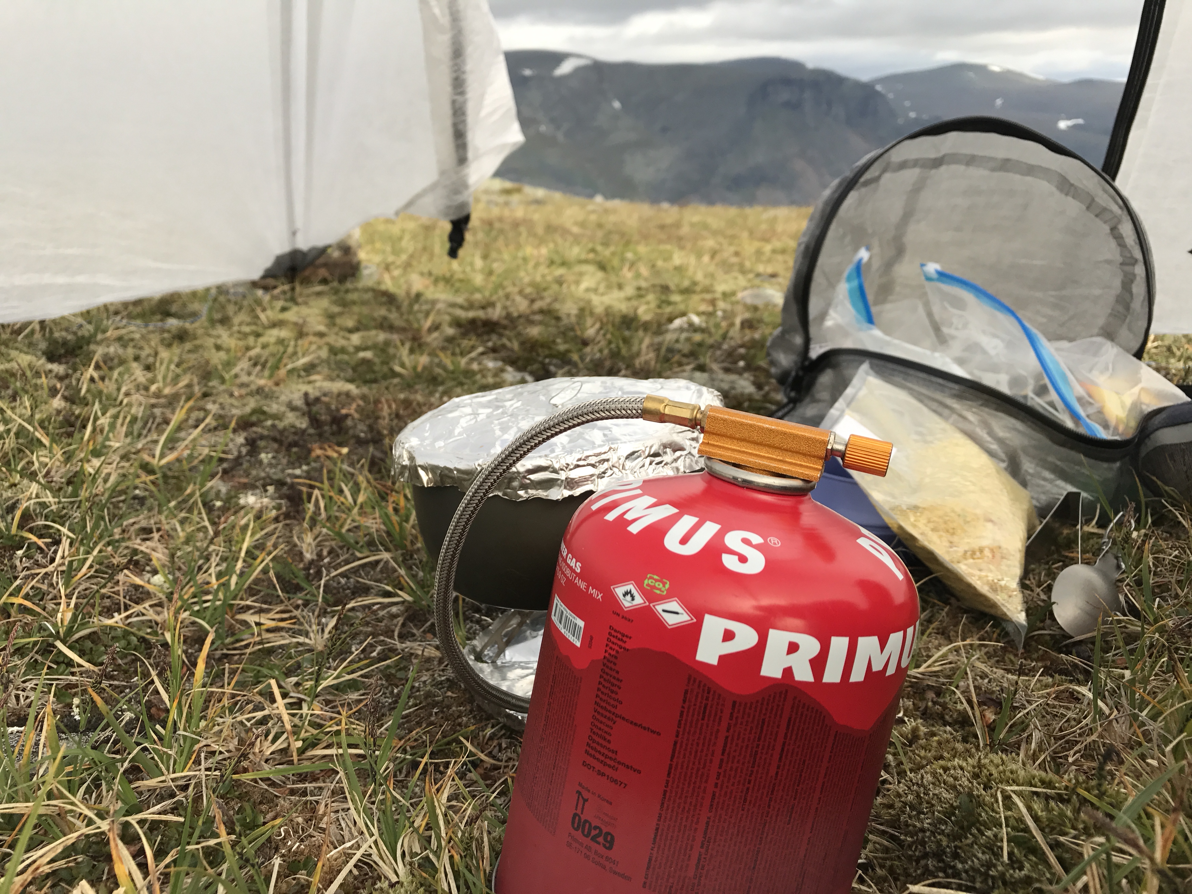
It had been getting colder during the day, and I put on my fleece, down jacket, wind jacket and my down booties. Boiling water was a pain, and my fingers got numb from trying to heat up the gas canister. Despite me having under my jacket to keep it warm. I was however able to make dinner eventually. I also boiled water to keep in a bottle wrapped in socks as a radiator in my sleeping bag.

I went to bed and slept quite well during the night. As so often, I woke up around 4-5 o’clock, feeling cold. I put on my fleece jacket and went back to sleep. I think the temperatures dropped down to around -7 to -8°C during the night.

When I woke up I really had to struggle mentally to make myself leave the comfortable warm sleeping bag and get outside in the cold. I did it gradually, and boiled coffee while still in the sleeping bag. I had brought Growers Cup coffee, which tastes really good, and can be reused. I had brought one, and the refilled it with regular coffee during the trip.

I left camp around 9.30, and hiked through the forest in beautiful weather. I could see the sky for the first time this trip, and the air was really crisp and cold.

I walked the last stretch back to the car, and at the parking lot I met three peoplewith a dog, that was going to do a short day hike. My footsteps had been the only once I’d seen in the park, which means that during my time there I’d had 55km2 of beautiful forest all to myself. I really wish I could get back here more and I would have loved to stay here a couple of more nights.

It was a great start of the year, and I hope it only gets better.

Sarek in August; Part 7

Day 8

We woke up early, and by 08.30 we were almost done packing. This days planned route was over the plains, hiking north of the mountain Njunjes and then camp near Gidátjårro, just above the timber line. After a rough calculation I figured it would be something like 15km.

20170813_075438696_iOS
There’s something special about snow covered mountains

After an hours hike, we took a break. By then we had hiked approximately 4km. We took aim at Bastoajvve, a mountain just north of Skierffe, and hiked across the plains. Our goal was to cross the stream Ábbmojåhkå before it became too wide and fast flowing. As we came closer, the ground became more and more wet, and eventually my feet were soaked.

We came to Ábbmojåhkå just before 11.00, and I found a place that looked shallow, and the currents didn’t look so bad. I started to ford Ábbmojåhkå, but the water was deeper and the currents more powerful than I thought. When I was halfway over the water was up on the upper half of my thighs, and the currents was about to knock me over several times. Fredrik just shook his head, and decided not to go over there, but proceeded up Ábbmojåḧkå to find a better place to cross instead. After crossing the stream we were back in Sarek.

20170813_104848
Fording Ábbmojåhkå (Photocredit Fredrik Storm)

20170813_104931
It’s getting deeper (Photocredit Fredrik Storm)

We continued up to Njunjes, and ate lunch on the mountainside after we passed a locked Sámi hut as we exited Sarek again.

20170813_085247836_iOS
Ábbmojåhkå

After we’d lunch, we continued to go, and after a while a herd of around 60 reindeer came in front of us on the ridge line above us. They started to walk towards us, and when they were 10-20 meters away, they split up in a half circle and passed us on both sides and closed the circle behind us. It was a cool feeling to be in the middle of the herd as it passed us. I thought I was filming but I had accidentally double clicked my phone so I ended up with one second when they were closing in, and just filmed as they had already passed us.

We continued upwards towards Njunjes, and since we had hiked faster than we anticipated we decided to continue all the way to the car.

We walked straight up on the top Doaresoajvve, and even though it’s not a large top, it still offered some great views.

20170813_111335332_iOS
Not the highest peak, but still great views

20170813_111326342_iOS
Fredrik on Doaresoajvve

The hike up on the north western side was a piece of cake. The way down on the east side, however, was much steeper. There was also snow that we needed to get through to get down. I kicked in footsteps into the snow, but ended up with my ass down and slid straight towards the sharp stones below. I managed to get down without damage. However, the snow was covered with reindeer poop. When I looked up I saw a two meter long ass-shaped poop-brown track that went down towards the rocks. I had reindeer poop over my pants, backpack and hiking poles. I heard Fredrik saying a silent “Hell no” to himself, and he looked for another way down.

After the steep passage with the snow we had some easy walking again. We were soon to cross Kungsleden, and could see a group of hikers having a break on the trail.

We crossed Kungsleden and continued east. After a while we turned north to reach the trail that was just below the timber line in Ultevis fjällurskogs naturreservat. We reached the trail and thought that it would be an easy quick hike back to the car. It wasn’t. In the end it felt like a death march, and we were both tired and sore. We regretted that we hadn’t stopped on Doaresjoajvve instead of forcing our selfs like this. But once you’ve set your mind into going home, and eating real food, it’s hard to change it.

20170813_130446544_iOS
Down below timer line for the first time in a week

When we finally reached the car at around 18.30, we filled up on water, and changed clothes. I was able to get somewhat clean with water and wet wipes. When I draw our route on my Fjällkartan app it turned out that we had hiked approximately 40km.

We drove to Jokkmokk and bought chicken- and gyros rolls. I’m sure they weren’t the best ones out there, but right then they tasted like heaven.

We kept driving for a few hours, and around 22.00 we just settled for the first open space we could find. A gravel spot in a clear cut. It was the worst camp site ever, and we would have been flooded if it had rained. It was a bad end to a good trip. First hiking like we were escaping death, and then end up camping on in a gravel pit.

The next day we drove to Bollnäs and enjoyed the hospitality of Fredriks grandmother, before driving the last ~700km back home the day after that.

Final thoughts

I had a really great trip, and I definitely have to come back to Sarek again. Was I disappointed that we didn’t go the route we had planned? Yeah, maybe a little. It was nice to do more of a camping than hiking type of trip. And I really needed to learn how to take breaks, since I often push myself hard while hiking. But I did get a little bored with camp life after a while. And I would have liked to see more of the inner Sarek.

In the end I’m pleased with the trip and I had a great time. I’m also glad that I finally got the quilt to work without having cold drafts, and it was nice to try the HMG Ultamid in harsh conditions.

I hope this trip report has been interesting, and I’ll post a post-hike gear review later on.

Sarek in August; Part 6

Day 7

I slept relatively well all night long, despite the hard winds outside the tent. I woke up every now and then, and noticed that there was less and less air left in the sleeping mat. I thought it might be a small hole in it, but was too tired to get up and check for it. In the end it had leaked so much air that I had to check it. When I looked at the valve, I saw that the inflate valve was open, and remembered that the straps for the quilt had stuck when I put it on the sleeping mat. The check valve was the only thing that had prevented the air from leaking too quickly. I inflated it again, closed the valve and went back to sleep. It kept the air for the rest of the night.

We got up before 08.00, and at 09.30 we left the campsite after restoring the camp site and dismantling the stone walls we built around our tents as wind blocks.

We hiked back over Alep Válak and passed the Sámi hut again. A large herd of reindeer were grazing near the hut, but slowly moved south when we where closing in. As soon as we came below Alep Válak, the wind died down. The weather also improved, even though we saw dark clouds beyond the mountains.

20170812_075611571_iOS
Hiking in the outskirts of Sarek

20170812_095658
Me in the outskirts of Sarek (Photocredit Fredrik Storm)

We hiked on the slopes of the mountain Tjålle, on the eastern side of the stream that marks the border to Sarek. We had now exited Sarek, and from what I can gather, the lands we where in now were neither a national park nor a nature reserve.

We planned to round Tjålle, and look for a camp site between Tjålle and Skämmabákte, but with a view over the lake Sitojaure.

The sun was shining occasionally, but when we sat down for lunch, on the southern side of Tjålle, it started to rain heavily. We took out our rain clothes and ate in the rain. It continued to rain while we walked, but eventually the clouds disappeared and the sun warmed us again. The weather in the mountains does change quickly, and it feels like you can have all four seasons of the year in just a few hours.

20170812_095146039_iOS
We had lunch here, but despite the seemingly blue skies it started to rain

We had a beautiful easy hike, on soft green grounds that was pierced by several streams of different sizes.

We talked about the route we would take on our way back to the car, and decided to camp one night more after this, and then go home. We would then drive for a few hours and pitch our tents, to avoid having to drive 12-13 hours the following day to reach Fredrik’s grandmother in Bollnäs.

20170812_130813
The plains were beautiful, and easy to walk on (Photocredit Fredrik Storm)

This meant that the trips would be shorter than the 10-12 days we had planned, but when we did not go the planned route I also had difficulty keeping my motivation up for more days. I missed talking to my family, and really missed my kids. Since they left for Greece this day, I knew I had to settle with seeing them on FaceTime.

We found a nice flat place overlooking Sitojaure and close to a larger stream, and camped there. The time was only 14.00, so it was early for us. Even though it wasn’t as windy as in our last camp site, we still had quite a bit of wind in the beginning. We secured the tents with rocks on the pegs, although we did not feel the need to build a massive wall around the tents as we had the night before.

20170812_171918420_iOS
A nice camp site outside of Sarek

Throughout the day we had seen and heard a lot of grouses near us. In the afternoon one of them sat close to our camp and chirped endlessly.

20170813_072421
Our camp (Photocredit Fredrik Storm)

It was Saturday evening. The last time we saw anybody else was on Tuesday evening, with the people that set up their tents on the other side of Nammásjjåhkå. It’s really desolate here. At least in the places we chose to hike in.

20170812_143715035_iOS
Making a more luxurious dinner than usual; Flying Jacob

We planned the route for the next day, and estimated that it would be a 15km hike in fairly easy-going terrain. I was glad that it would be a bit longer than our previous days, since I’m starting to get a little bored of staying in the camp so much. I like to hike, and would like to go all day just to camp, eat, read an hour and then sleep. I did like to have a change of pace, hike slower and take more breaks, but eventually I felt like hiking more. I like to hike long days, and go to bed with a tired sore body.

20170812_152320645_iOS
Planning the last leg of the trip

I read a lot, lying or sitting, inside or outside the tent. The wind had blown quite hard earlier when we had set up our tents, but it had died down during the evening. The lack of wind caused mosquitoes and flies to emerge. Some of them came in under the fly, while many of them sat on the outside of the fly. The weather had been fantastic this day, but every time we looked over the border into Sarek, it looked like it was the end of days over there, with almost pitch black clouds covering the area.

Sarek in August; Part 5

Day 6

We made breakfast and broke camp with no hurry at all. Fredrik was faster than me this morning, and looked a bit restless while I packed. I had been having problems with headaches during the night, and therefore lay down for a long time in the morning until the pain meds kicked in.

We filled up our water bottles and started hiking north, towards Alep Válak. We had planned to pitch our tents with a view of the lake Sitojaure. It was only a short hike from our previous camp site, about two to three km.

20170811_094605582_iOS
View from Alep Válak, with the stream Sijddoädno in the middle of the photo

It didn’t take long to go there. The ground was flat, albeit littered with boulders and pierced by melting water from snow and glaciers on Rådnik and Dágarlåbddå. On our way towards our new camp site we passed a locked hut that the Sámi use when they’re tending to their reindeer herds. We were hiking just along the eastern border of Sarek.

Around 12.00 we arrived and found a good place to set up the tents. The view was amazing with Sitojaure some 500 meters below us, but we were both aware that the location was anything but ideal when it came to wind. The valley with Sitojaure goes in a north-west to south-east direction, and in the north-western end of the lake there is another valley in the north-south direction. We had a lot of open areas and not much wind protection.

20170811_105233574_iOS
Great view, and (in the beginning) nice weather

20170811_105158004_iOS
I built a wind cover from the surrounding rocks

It blew really heavily, but our camp site was filled with large rocks, and we anchored the tents well, and also built wind guards around the perimeter to reduce the amount of wind that would enter under the fly, and also relieve some stress from the anchor points.

The weather had been great in the morning. Sunny and much warmer than the day before. Once we had set up the tents, dark clouds came towards us, and soon the whole sky was covered with gray rain clouds. A slight drizzle fell over us.

We had lunch in our tents, and then went out and looked more at the view. Fredrik had found a small stream a few hundred meters from the camp site. A  patch of snow, still unmelted, formed a little stream of water that we could fill our bottles from.

20170811_110219160_iOS
Dinner with a view

It rained on and off during the day. Hard wind-driven rain. We laid in our tents and read, and this day was the first one that I cooked inside my tent. I have used the floor over the entire surface to reduce condensation earlier. But with the wind on this location, condensation was no problem, so I only put polycro under the sleeping mat.

20170811_142321725_iOS
We had a rainbow between the rains

During the night, the wind blew even worse. I went to bed at around 20.30, prepared for another sleepless night, but actually slept pretty well. I used the down jacket as a pillow instead of the inflatable pillow, and it worked better and was much more comfortable. It was in a dry bag that was a bit open to be able shape it better.

I felt a little worried about the tent, and if it would hold up, but I decided to break those thoughts. If it was to happen then I would solve the situation then. And I’ve seen videos of Ultamids standing up in severe snowstorms in Alaska, and this was nothing compared to that. I slept relatively well all night.

I made a short video to show how the tents held up in the wind.


Sarek in August; Part 4

 Day 4

I slept very bad all night. It took a long time for me to fall asleep, and when I finally did, I slept shallow and woke up a lot. It was raining all night. When it was time to get up, it had stopped raining, but the wind blew quite hard. We had camped just east of the top Suokitjåhkkå, and had now planned to round it on the north side, below the top Niehter. We had a calm morning, chilled and took our time to get ready. Eventually we  broke camp and started walking. Two tents were set up on the other side Nammásjjåhkå, and we had seen four people near them the night before, but now we saw no one there.

20170809_065322185_iOS.jpg
A herd of reindeers passing our campsite

The day began with boulders, but fortunately they were neither wet nor at a 45° angle so they were easier to walk on than the ones we had the day before.

20170809_084924344_iOS
Passing between Suokitjåhkkå and Niehter

When we rounded the top Suokitjåhkkå we reached a plain west of it. The ground was easy to walk on, even though there were a lot of rocks spread out. We stopped to have lunch here, with a great view of the snow covered tops of Gådoktjåhkkå and Bielloriehppe.

20170809_091439009_iOS
Fredrik, on the plains west of Suokitjåhkkå

20170809_100745798_iOS
A nice view while making dinner

20170809_091550815_iOS
Me, enjoying the views of inner Sarek

20170809_091658658_iOS
Gådoktjåhkkås top covered in clouds

We had planned to go north between Niehter and Rådnik down to the lake Niehterjávrre. On the map it looked like it would be nice to camp there, with a lot of flat ground.

As we kept hiking the boulders got worse, and eventually we ended up in a seemingly endless ocean of rocks. We didn’t move fast at all. When we finally passed the highest point between Niehter and Rådnik and saw the lakes below, we realized that it would not be possible to pitch any tent there there. As far as the eye could see, there was only rocks. We saw on the map that the last of the three lakes below had an outlet that led down to a plain. This was the same plain as we seen from the camp site at Skierffe. We took aim at the far end of the last lake and kept walked. It was a desolate landscape, and we walked quietly some 30 meters apart. Each of us buried in our own thoughts.

20170809_133553
Coming up on the highest point between Niehter and Rådnik (photocredit Fredrik Storm)

20170809_140743
Looking down towards the plains where we hoped to find a good camp site (Photocredit Fredrik Storm)

20170809_132812618_iOS
The endless boulders took its toll on our feet and ankles

I was beginning to feel bad in my stomach, and started to feel dizzy too. I hoped it would be something I ate, but I was worried that I might have gotten some bad water. I’ve never used a filter in the mountains, and I don’t know anyone who does. But traces (and poop) from reindeers were everywhere, and I was worried I might have drunk poop water.

At the far end of the last lake water flowed down a slope, and below there were extensive fields with possible tent sites. We continued north and found a suitable place, west of the mountain Tjålle. There was a lot of snow left in the mountain above us, so much of the ground was saturated and carved down by melting water. But we found a good place to put up our tents.

My stomach was acting out for a while, but finally calmed down. I laid down and read for a while and then went to sleep. I had a hard time getting used to the light, and that it never gets really dark. It was difficult to fall asleep, and I slept shallow this night too and woke up a lot.

It never gets really dark. At 22.00 it is still bright as day. When I wake up at 4, it’s already just as bright. Somewhere between 01.00-02.00 it’s somewhat dusky, but never really dark. You don’t need a headlamp if you wake up and have to pee.

I have to admit that I was not really prepared for how the constant absence of darkness would affect my sleep. But the constant light gives an almost surreal feeling that messes with the sleep rhythm.

Day 5

This day we stayed in the same place as before. I had washed my underwear and socks in a zip lock bag the night before and hung them up in the tent. The idea was that they should dry during the day. The weather was bad for almost all day, with heavy rain that came and went on a regular basis. I laid in the tent and read almost all day, and so did Fredrik in his tent.

20170809_174034530_iOS
Drying my newly washed clothes

When I went to bed, I had trouble falling asleep. I tossed and turned, had a headache and a sore throat. Suddenly my sleeping mat made a sound, like it got punctured.

I got off it and saw that it was much softer than before, and assumed that it was a puncture. I blew it up to check the leak, but discovered that it was the lamination in one of the baffles that had burst, and now a large channel of two was formed. Fortunately it wasn’t in the middle, so I was still able to use the sleeping mat, although it was more uncomfortable than before. I was a bit disappointed since I hadn’t even had the sleeping mat for 3 years. I’ve always been careful about it and haven’t filled it up too much.

20170810_161115349_iOS
Our campsite for night four and five

I’ve slept bad since we came to Sarek. I think the light makes it difficult for me to sleep, and sleep deprivation leads to migraines that make it even harder to sleep.

At least I slept somewhat ok this the night, even though I fell in and out of sleep all the time. It blew hard during the night, and there was a lot of wind coming in under the fly. It had been really cold during the whole day and night, and almost felt like it was approaching freezing.

Sarek in August; Part 3

Day 3

We woke up quite early. Just like the day before, both of us woke up at 04.30 because it was already bright as day. But I fell back to sleep. We finally got up before 08.00, made breakfast and packed up. We had decided to follow some of our original route, and go west along the Rapa Valley, south of the mountain Gierdogiesjtjåhkkå. We went down from Skierffe and came to an vast plateau at about 1000m altitude. The ground was flat and easy to walk on, and there were possible camp sites everywhere. We saw that the plains stretched far away in the north, and decided that we would hike there on our way back to the car in the end of the trip.

20170808_055608325_iOS
My sleep and shelter setup: HMG Ultamid 2 with a polycro groundsheet, Exped Synmat 7 UL with a Cumulus Quilt 350

After walking in the hiking paradise in the plains in the morning, the rest of the day turned out to be the opposite. The guidebook I read before we went showed that we could hike the route we took, and keep going along the 1000m altitude line. But we found out the hard way that this meant hiking through brushy terrain on slippery rocks and boulders at a 45° angle.

20170808_122753
It started with brushes, but got more rocky and steeper the farther we went (photocredit Fredrik Storm)

I fell pretty bad once when stones shifted under my feet, and I my leg got stuck down to my thigh, with more rocks falling on it. But I got loose with only a few scratches. A while later I slipped and fell on a rock, and accidentally smacked myself hard in the temple with one of my hiking poles. I had to sit and rest for a while after that one.

We were both tired, and traversing this kind of terrain took a lot of effort. You had to weigh every step to make sure that the stones wouldn’t move. We took a lot of breaks.

20170808_131753
Looking back towards Skierffe (photocredit Fredrik Storm)

The weather had been very nice in the morning, but gradually became worse. In the end the rain came, and it rained on and off the rest of the day. The rain didn’t make the traverse any easier, since the rocks just got more slippery.

20170808_114325316_iOS
Fredrik looking back at the Rapa valley delta, with the mountain Tjahkelij in the background

Eventually we reached the stream Nammásjjåhkå. From where we were standing there was no way we could pass. There was a tall waterfall, and steep cliffs down towards the water. We first tried to hike higher up, and see if we could pass above the waterfall, but the cliffs where to steep for us to be able to get further up. We looked further down, and saw that it was possible to pass at the end of the waterfall, just below the timber line.

20170808_122434136_iOS
Fredrik looking over the edge to find somewhere to pass Nammásjjåhkå

It was a steep way down to the water, but we slided down on our butts, and managed to get down to the stream. As I crossed it, I almost slipped on the slippery stones, and decided not to try to balance but went straight through the water instead. I wore my quick drying trail runners to be able to do just that and not worry about them being wet.

We took a short break after we had forded the stream, and reviewed our plan for how we would proceed.

The mountain side was still quite steep, but it would be flatter on a higher altitude, so we decided to hike in a diagonal line upwards to reach the flatter grounds.

It went slowly uphill, and the terrain was difficult and brushy. We eventually reached a somewhat flat area where we stopped. The sun started to shine and warmed us, and it made wonders for our morale. The sky turned blue, and beneath us in Rapa valley we saw clouds forming. We did however realized that they would rise and we would be surrounded by fog, so we continued hiking as far as we could before the fog reached us. When it finally reached us we just rested until it was gone.

20170808_142728798_iOS
Clouds forming in Rapa valley and rising to our position. Mountains from left to right: Skierffe, Tjahkelij and Nammásj

We found a nice plateau to set up camp, but it was too far from a water source. We continued to a new plateau near one of the side streams to Nammásjjåhkå. While we were setting up the tents, we saw dark rain clouds approaching fast from Rapa valley. We quickly set up the tents and anchored them with the surrounding rocks. Just when the tents were up the rain came. It rained heavily so we took refuge to our tents. I was to tired to clear out a space to cook dinner in the tent, and just ate three sausages and a protein bar instead, after changing from my cold wet clothes to my dry sleeping clothes. After “dinner” I crawled in under the quilt and read for a while. The rain was still falling outside.

Just after 19:00 it stopped raining and we went out. Five reindeers were standing just ten meters from the tents. While we were out, a couple of guys came from the other side Nammásjjåhkå. They crossed the stream and continued westward. We saw four more people coming on the other side, but they camped there instead of crossing. Both groups were hiking at a higher altitude than we had done during the day, and the ground was flatter there. We assumed that we should have the same thing, as it seemed to be an easier route than ours.

20170808_173240237_iOS
Camp site 3. We had nice views here too

Just after 22:00 a loud noise was heard. I looked under the edge of the shelter and saw that a large herd of reindeer was passing just outside. It was a cool sight, but I was too tired (lazy) to crawl out of my sleeping bag to go out and take photos of them. 

Sarek in August; Part 2

Day 2

I woke up a few times early in the morning as it was already bright as day outside. I was using my Hyperlite Mountain Gear Ultamid 2, and a thin layer of white, semi transparent Dyneema composite fabric doesn’t do much to block the sunlight. When I looked at my clock, it was only 04.30. I went back to sleep, and we got up at around 09.00 instead. We made breakfast, broke camp and went up to the STF cottage to pay for our stay. A couple of hikers had pointed us to the right cabin. The lady who smoked when we arrived sat on the stairs of the nearby cabin, looking at us.

20170807_064224779_iOS
My Ultamid 2 and Fredriks Bergans Trollhetta 4 in the background

20170807_074325726_iOS
My gear: In the bottom of the pack I have an Exped Schnozzle bag (the yellow one) with my sleep gear. After that two large Pack pods with food. Above those I have toiletries (neon bag) and electronics (zip lock bag). Tent (white bag) and extra clothes + down jacked (red one) next to each other and at the top I have a small Pack pod with my stove set and food for the day. All packed in a HMG Southwest 4400

When we got hold of the hut warden, he told us that it was prohibited to camp where we had pitched the tents. The ground, and the hut near it, did not belong to STF, but to the Swedish Nature Conservation Association. We did not have to pay because we did not camp on STF’s land. However, it felt a little embarrassing to have camped where we weren’t allowed to. But since the woman in the hut didn’t say anything, perhaps it didn’t matter. She had heard us talking about paying and looking for hut warden, both during the evening and during the morning, so I suppose she understood that it was a misunderstanding.

Our goal for the day was to get to Skierffe. A mountain with an almost 700 meter vertical wall right down the Rapadalen.

20170807_140304
Me, on our way towards Skierffe (photocredit Fredrik Storm)


We got up through the woods, which gradually changed from spruce to birch forests, and then disappeared completely as we reached above the timber line. 

Fredrik and I have a different hiking philosophies, where I am a lightweight hiker who like to march on at a fairly good pace, and hardly even want to stay for lunch. Fredrik packs quite heavily, likes to stop more often, and wants to spend more time chilling and just enjoying the moment, instead of trying to get a lot of km behind him.

20170807_123526451_iOS
The snow covered mountains of Sarek


It was important to me to get back home in time, since my wife took the kids to visit her relatives in Greece and I was to pick them up at the airport when they got back. I realized that we would probably not be able to do our planned hike without having to stress it in the end, so we agreed to skip the plan and instead just go where ever we felt like for the day, take a lot of breaks and not care about the mileage. The only goal was to be back at the car at least 10 days later. It was a bit of a change of philosophy for me, but still felt nice. However, it meant that I had packed way too much food. But it still felt ok, although it meant carrying some unnecessary weight.

When we were coming close to the top of Skierffe we ​​decided to start looking for a camp site, even though the clock was only around 14.00. We passed the trail and continued towards the western side of Skierffe. There we found a really good camp site, with flat ground for both of our tents, and a lot of stones to anchor them. We could have saved weight sharing tents, but both Fredrik and I prefer to have our own space.

20170807_140143109_iOS
One of our best camp sites ever

The camp site had a very nice view over Sareks snow covered peaks. The wind blew hard when we were setting up camp, so we anchored the tents well. I wanted to go to the top of Skierffe, but Fredrik preferred to stay in camp so I went by myself. When I got up at the top there was a young family there with their child in a child carrier.

20170807_142854563_iOS
The river delta in Rapa valley

The view from Skierffe was amazing. It was uphill almost all the way up to the cliff. Then came the long cliff all the way down to Rapa Valley. It was a majestic view, and well worth the effort to get there.

I walked back to the camp and after a while we made dinner.

We went looking for water, and found a little stream a couple of hundred meters away from the camp. Fredrik went to bed quite early, but I laid on the CCF mat and read for a couple of hours. When the wind stopped, it was almost completely quiet around us. It is not often you get that silence when you live in a town. Traffic, sirens, lawnmowers, people talking, airplanes. There’s always noise, and it was refreshing to hear nothing like that.

I went to bed around 21.00, but went out for a while after 22:00 to check out the sunset. By then it had already disappeared behind the mountains, though it was still bright outside.

20170807_195220094_iOS
The sun had just disappeared behind the mountains


I went to bed and sleep pretty well. The new way of attaching the quilt has worked very well, and I have not had any drafts, even though I tossed and turned a lot and it was cold in the morning.